- バーコード
- 0000025150
- IGPS番号
- 79057
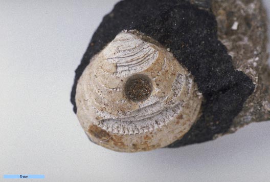
- 学名 12
- Glycymeris oshimaensis Noda, 1962
- 産地(英)
- Loc. No. 924 (Noda, 1962), Road side cliff, about 300 m E of the pass between Oshima and Hosono, Matsunoyama-machi [sic, between Oshima-mura and Yasuzuka-machi], Higashikubiki-gun [currently between Kamitate, Oshimaku and Hosono, Yasuzukaku, Joetsu City], Niigata Prefecture
- 産地(和)
- 新潟県東頚城郡安塚町細野-大島村上達(上越市安塚区細野-大島区上達)間の道の約300 m東方の道路脇の崖 Loc. No. 924 (Noda, 1962)
- 緯度経度
- -
- 層準
- Kubiki Formation (頸城層)
- 時代
- Middle Miocene
- 採集者
- H. Noda
- タイプ標本
- Holotype
標本情報
- 学名
- Glycymeris oshimaensis Noda, 1962
- 出典
- Sci. Rep., Tohoku Univ., 2nd Ser. (Geol.), Vol. 34, no. 3, p. 229, pl. 16, fig. 8
- 登録番号
- Holotype: IGPS no. 790578
- 産地
- Loc. No. 924, Road side cliff, about 300 m E of the pass between Oshima and Hosono, Matsunoyama-machi, Higashikubiki-gun, Niigata Prefecture
- 層準
- Kubiki Formation
- 時代
- Miocene
- 備考
- -
文献情報
© The Tohoku University Museum all rights reserved.