- バーコード
- 0000025204
- IGPS番号
- 77373
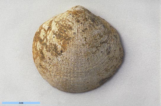
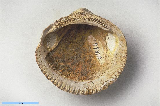
- 学名 12
- Glycymeris yamaguchii Hayasaka, 1956
- 産地(英)
- Loc. No. 1 (Hayasaka, 1956), cliff of the Takasegawa River west of Takakura, about 5 km SW of the Namie-machi Railroad Station on the Joban Line, [Ide,] Namie-machi, Futaba-gun, Fukushima Prefecture
- 産地(和)
- 福島県双葉郡浪江町井出高倉の西 常磐線浪江駅の南西約5 kmの高瀬川の川崖 Loc. No. 1 (Hayasaka, 1956)
- 緯度経度
- -
- 層準
- Ishiguma Formation (石熊層)
- 時代
- Pliocene
- 採集者
- S. Hayasaka
- タイプ標本
- Holotype
標本情報
- 学名
- Glycymeris yamaguchii Hayasaka, 1956
- 出典
- Saito Ho-on Kai Mus., Res. Bull., no. 25, p. 16, pl. 2, figs. 1a-2c
- 登録番号
- Holotype: IGPS no. 77373 (figs. 1a-c)
- 産地
- Loc. No. 1, cliff of the Takasegawa River west of Takakura, about 5 km SW of the Namie-machi Railroad station on the Joban line, and Loc. 2, path side cutting at Onoda, aboout 2.5 km NE of the Loc. No. 1., Namie-machi, Futaba-gun, Fukushima Prefecture
- 層準
- Ishiguma Formation
- 時代
- Pliocene
- 備考
- (Secondary homonym: Glycymeris hayasakai Ogasawara (MS) (n. n.))
文献情報
© The Tohoku University Museum all rights reserved.